Arizona Practice Areas and Reporting Points
We want your feedback! Click here to let us know if you think there is something we should add or change.
Instructions and Disclaimers
Please carefully review all of the information on this page.
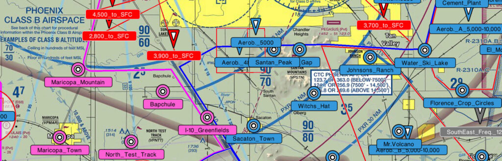
This page contains AFTW recommended practice area reporting points and procedures for the Phoenix-area, Northern Arizona, and Southern Arizona. Each pilot has the responsibility for knowing and following all required FAA practices and procedures.
Always practice FAA-recommended visual scanning procedures, even when communicating on practice area frequencies and utilizing ADS-B traffic information.
Remember that not all pilots know about these practice area frequencies and reporting points.
Please direct any pilots who are operating in the Phoenix-area to this site.
ForeFlight and Garmin Pilot GPS Overlays
- Arizona Reporting Points Overlay (Direct Link / Google Drive Link) – Updated November 8, 2025
- Legend
Other Overlays
- DVT/Luke SATR LOA Sector ForeFlight/Garmin Pilot Overlay – Updated November 14, 2018
- Explanation of DVT/Luke LOA (Official LOA)
- IWA Night Sector
- TFD Night Sector
PDFs of Phoenix Practice Area Charts (last updated January 8, 2022)
VIDEOS: How to Download and Use the Overlays
ForeFlight
Garmin Pilot
Practice Area Videos
Thank you to Emmanuel Tempelman for providing these excellent videos!
- Northwest Practice Area Video
- Northeast Practice Area Video
- Southwest Practice Area Video
- Southeast Practice Area Video
- Rainbow Valley Practice Area Video
Northern Arizona Practice Areas and Procedures
Southern Arizona Practice Areas and Procedures
Other important information from various operators…
Arizona Skydiving Operations
- Current Information (Google Doc)
- We did this with a Google Doc so that each operator can easily update their own information as needed
- If you run a skydiving operation in Arizona, please contact the AFTW to get Editor access to the Google Doc
- Please spread the word to pilots and other skydiving operators. Thank you!
Aviation Performance Solutions (APS)
- APS operates high-performance aerobatic piston and jet aircraft on the east side of Phoenix
- Please watch this 14-min Flight School Awareness Video for a detailed briefing
- KML file showing airspace boundary used by the Extra 300 fleet (6 to 10,000′ from 6 am to noon during summer months and 8 am to 3:30 during winter months)
KIWA – Allegiant RNAV Visual Approach Procedures
- Allegiant RNAV Visual Rwy 12C Approach Procedure
- Allegiant RNAV Visual Rwy 30L Approach Procedure
- East Valley Airspace Hazards
Luke AFB / Rainbow Valley Memorandum of Understanding (MOU)
- The official MOU only applies to certain operators
- All pilots are encouraged to follow these procedures
- Click HERE for the MOU
No-Maneuver Zone
- Click HERE for the PDF
United Aviate Academy (UAA) Arrival / Departure Procedures
- UAA (callsign Varney) operates the following procedures under a Letter of Agreement (LOA) with GYR tower
- The procedures have been made available here to enhance awareness and safety
- Arrivals
- GAP Arrival
- Gila Crossing Arrival
- Glendale Power Plant Arrival
- Luke AUX 6 Arrival
- Departures
- Buckeye Departure
- Gila Crossing Departure
- Glendale Power Plant Departure
- Twin Lakes Departure
You must be logged in to post a comment.