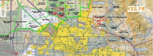
 The Arizona Flight Training Workgroup needs comments from flight instructors and others who fly and train regularly in the southeastern Phoenix metropolitan area.
The AFTW is redrawing its popular chart depicting practice areas over the PHX area, and your comments will be used to help increase safety over airspace that both commercial jet traffic and training flights currently share.

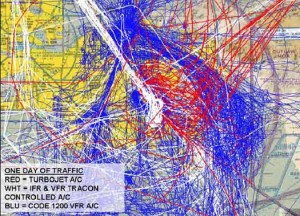
The blue tracks indicate VFR aircraft squawking 1200, red tracks depict large turbine aircraft arriving or departing IWA, and white tracks represent other aircraft being provided air traffic services by Phoenix TRACON.
In January, Federal Aviation Administration officials, pilots and instructors identified the airspace east and southeast of Gateway airport (IWA) as a safety concern. That’s because growing commercial jet traffic and flight training activities use that same space. (See related post.)
The AFTW flight-training charts contain overlays onto the PHX Terminal Area Chart and PHX sectional highlighting recommended frequencies and hot spots, and other details vital to flight training safety.
You can see the current charts at this link: http://aftw.org/wp/2011/04/reportingpoints201/
Please leave a reply at the bottom of this post with your suggestions for changes to the current charts. The AFTW will use your comments in a new issuance this year.

You must be logged in to post a comment.